
High-resolution maps of air pollutants
Downscaling satellite observations
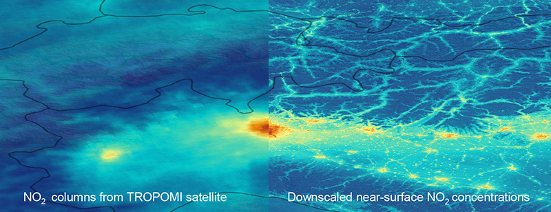
The Sentinel-5P/TROPOMI satellite instruments measures NO2 maps at 6 km resolution, which is already quite high but still coarser than the required 1 km resolution. In addition, since remote sensing instruments measure vertical columns instead of near-surface concentrations, we developed machine learning algorithm that downscale TROPOMI NO2 observations. Our algorithm creates hourly maps of griddied near-surface NO2 concentrations at 100 m resolution. We used the extreme gradient-boosted tree ensemble method, which was trained with in situ NO2 ground measurements to predict NO2 concentrations using NO2 satellite images, land use data, meteorological fields and topographical information. The maps can be used as input for air pollution control and epidemiological studies.
GAW Symposium 2021, Session 3 from Minsu Kim on Vimeo.
Airborne imaging remote sensing

Publications
- Kim, M.; Brunner, D.; Kuhlmann, G. Importance of satellite observations for high-resolution mapping of near-surface NO2 by machine learning. Remote Sens. Environ. 2021, 264, 112573 (13 pp.). https://doi.org/10.1016/j.rse.2021.112573

